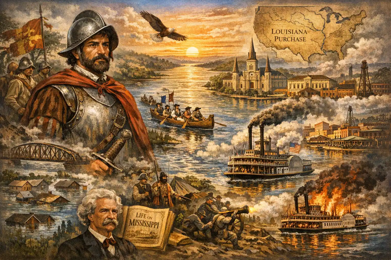
How Hernando de Soto’s 1541 discovery of the “Big River” shaped American geography, commerce, and culture for nearly 500 years
On May 8, 1541, Spanish conquistador Hernando de Soto stood on the banks of a river so vast it seemed to stretch beyond the horizon. After months of brutal marching through Florida and fighting Native American tribes, his expedition had stumbled upon what the Ojibwe called the Mississippi—”Big River.” De Soto had no idea he was looking at what would become North America’s most important waterway, a 3,770-kilometer artery that would define American borders, fuel economic expansion, and inspire literary legends. The Mississippi River he discovered that spring day would shape the continent for centuries to come.
Today, the Mississippi ranks as the world’s 13th longest river, flowing through ten American states from Minnesota to Louisiana. Its basin covers approximately 3 million square kilometers across 31 states and two Canadian provinces—making it the ninth-largest river system globally. From its modest source at Lake Itasca, where the water runs less than a meter deep, to its massive bird-foot delta emptying into the Gulf of Mexico, the river represents one of geography’s most dramatic transformations. Yet its importance extends far beyond statistics. The Mississippi has been a highway for exploration, a boundary for empires, an engine for commerce, and a destructive force that repeatedly reshaped American settlement patterns.

European Discovery and Early Exploration
Hernando de Soto’s 1541 encounter marked the first European documentation of the river, though Native Americans had utilized it for millennia. The Spanish governor of Cuba had launched his North American expedition with ten ships and hundreds of men, seeking gold and glory. What he found instead was geographic immortality—the Mississippi River, which his chroniclers described with awe at its width and power.
De Soto died the following year, his body sunk in the river he had discovered to conceal his death from Native American allies. The Spanish never established permanent control over the Mississippi basin, leaving the river’s full exploration to later European powers. That opportunity fell to French naturalist René-Robert Cavelier de La Salle, who between 1681 and 1682 became the first European to navigate the entire river from source to delta.
La Salle’s expedition canoed the complete Mississippi River system, after which he made a momentous proclamation: the entire basin belonged to French King Louis XIV. He named the surrounding territory Louisiana, establishing French imperial claims that would shape North American geopolitics for a century. In 1718, French colonists founded New Orleans near the river’s mouth, creating a strategic port that would change hands between empires multiple times.
Imperial Rivalries and American Control
The Mississippi River valley became a flashpoint for imperial competition. By 1763, lands east of the river’s mouth passed to Britain while western territories remained Spanish. France regained the Spanish territories in 1800, only to sell them to the United States three years later through the Louisiana Purchase. After defeating Britain in the War of 1812, the United States secured complete control of the Mississippi corridor—unifying the river under single national authority for the first time in its history.
This transition proved crucial for American expansion. The river became the primary highway for westward settlement, connecting the agricultural interior to global markets through New Orleans. Whoever controlled the Mississippi controlled the economic destiny of half a continent.

Read More:
Geographic Marvel: The River’s Physical Characteristics
The Mississippi River originates in northern Minnesota at 530 meters above sea level, flowing generally southward until reaching the Gulf of Mexico. Its course is extraordinarily winding and unpredictable—so much so that Mark Twain called it “the world’s first deceiver” in his 1883 autobiographical trilogy Life on the Mississippi. The river repeatedly changed course throughout history, destroying some communities while creating fertile land elsewhere.
The river’s dimensions vary dramatically along its length. At Lake Itasca, its source, the Mississippi is just 6-9 meters wide and less than a meter deep. Minnesota’s state seal depicts St. Anthony Falls, formed just below this modest beginning. Near Lake Winnibigoshish in Wisconsin, the river reaches its maximum width of 17 kilometers—transforming from a narrow stream into a vast waterway.
The Ohio River, the Mississippi’s largest tributary, joins near Cairo, Illinois. This confluence divides the river into distinct sections: the Upper Mississippi (793 kilometers of shallow stretches and 1,069 kilometers of shipping channel) and the Lower Mississippi (approximately 1,600 kilometers to the Gulf). The upper section contains 43 dams, many generating hydroelectric power, with locks facilitating navigation. The lower river flows slower—just 2 km/h—creating different navigation challenges.
The Mississippi’s delta, nicknamed the “Birdfoot Delta” for its shape, spreads across southern Louisiana. This vast wetland ecosystem represents one of North America’s most important ecological zones, though human engineering has increasingly controlled its natural fluctuations.

Commerce and Catastrophe: The River’s Dual Nature
The Mississippi River has served as America’s primary commercial artery since the early 19th century. The first steamboat, appropriately named New Orleans, traveled from Ohio to New Orleans in 1811, inaugurating the steamboat era. By the 1830s, thousands of vessels crowded the river—carrying cotton, grain, passengers, and manufactured goods between the agricultural interior and coastal ports. At peak operation around 1850, over 5,000 cargo and passenger steamboats worked the Mississippi system.
This commercial traffic came with terrible costs. The Mississippi claimed lives regularly through boiler explosions, collisions, and sinkings. The worst disaster occurred in April 1865, when the overloaded steamboat Sultana—carrying 2,427 Union soldiers liberated from Confederate prison camps when designed for 376 passengers—sank near Memphis after three boilers exploded. An estimated 1,700 people died, making it the deadliest maritime disaster in American history, though largely forgotten because it occurred the same week as Lincoln’s assassination.
By 1910, railroad competition had reduced steamboat numbers to 560, but the Mississippi remained economically vital. Today, 172 bridges—pedestrian, automobile, and railroad—span the river, including the historic Government Bridge (1856) and James Eads’ revolutionary steel truss bridge with deep-water caisson piers (1874) near St. Louis.
Floods and Natural Disasters
The Mississippi River’s spring floods have shaped American history repeatedly. The catastrophic 1927 flood reached 9-meter depths, inundating vast areas for months, displacing 630,000 residents, and causing damages that transformed federal flood control policy. Severe floods recurred in 1993 and 2011, demonstrating the river’s continuing destructive potential.
The river basin’s geography creates unique meteorological hazards. Evaporation from the vast watershed contributes to cyclone formation, producing powerful hurricanes. Hurricanes Katrina (2005) and Ida (2021) both flooded 80% of New Orleans, revealing the vulnerability of river-dependent cities. The 1811-1812 New Madrid earthquakes—three measuring 8.0 on the Richter scale—briefly caused the Mississippi to flow backward, a phenomenon that terrified contemporary observers.
Mark Twain’s characterization of the river as “the world’s first deceiver” captured this duality: the Mississippi created economic opportunity while destroying lives and property through unpredictable flooding and course changes.

Read More:
Ecological Wealth and Modern Significance
The Mississippi River basin supports extraordinary biodiversity. Approximately 375 fish species inhabit its waters, alongside mussels and crabs. Coastal areas host black bears, opossums, foxes, eastern moles, armadillos, coyotes, minks, white-tailed deer, striped skunks, and American alligators. Seven national parks line the river, including Vicksburg Military Park (site of an 1863 Civil War battle), Natchez Historic Park (location of the world’s largest slave market from 1832-1863), and New Orleans National Jazz Park (established 1944).
The river valley’s thick silt deposits create extraordinarily fertile agricultural land. Corn, soybeans, rice, sugarcane, and cotton dominate cultivation, while cattle ranching and grape growing flourish in specific zones. This productivity comes with environmental costs: agricultural runoff creates hypoxic “dead zones” in the Gulf of Mexico, representing one of modern America’s most challenging ecological management problems.
The Mississippi supplies water to over 18 million people across 53 cities in ten states. This resource distribution across multiple climatic zones creates both resilience and vulnerability—ensuring diverse water sources while complicating coordinated management during drought or flood.

Cultural Commemoration and Contemporary Relevance
The Mississippi River’s cultural significance extends beyond commerce and geography. In October 2002, the U.S. Mint issued a commemorative quarter promoting Mississippi as the “Magnolia State,” featuring magnolia blossoms and the state’s 1817 founding date. In 2023, the Denver Mint released a dollar coin commemorating the world’s first lung transplant, performed at the University of Mississippi in 1963—connecting the river’s legacy to medical innovation.
From Hernando de Soto’s exhausted expedition in 1541 to modern flood management debates, the Mississippi River has remained central to American identity. It has been an avenue for empire, an engine of economic growth, a force of destruction, and an ecological treasure. Understanding its history means understanding how geography shapes human possibility—and how human engineering increasingly attempts to control natural forces that remain fundamentally unpredictable. The “Big River” discovered nearly five centuries ago continues flowing, its course still shaping the continent it divides.
Read More:
Primary Topics: Mississippi River, Mississippi River history, Hernando de Soto discovery, La Salle Mississippi exploration, Mississippi River geography, Mississippi River floods, 1927 Mississippi flood, Mississippi River commerce, steamboat history, Mark Twain Mississippi, Mississippi River delta, Mississippi River ecology, New Orleans history, Louisiana Purchase, Sultana disaster, Mississippi River bridges